Since 2014, the European Copernicus programme has launched a wide range of Earth Observation (EO) satellites, named Sentinels. The Sentinel mission is designed to deliver data for at least the next 15 to 20 years to monitor and forecast the state of the environment on land, sea and in the atmosphere. Copernicus’ objectives include the support of climate change mitigation and adaptation strategies, efficient management of natural resources as well as emergency situations, and improvement of the security for every citizen of the world. The ever-increasing amount of acquired data makes Copernicus the largest EO data provider and the third biggest data provider in the world. The data’s potential has already been shown by experts in several new or improved applications and products. Still, challenges exist to reach end users with these applications/products, i.e. challenges associated with distributing, managing, and using them in users’ respective operational contexts. Under the leadership of the Austrian Research and Promotion Agency (FFG), substantial funding through the Austrian Space Applications Programme (ASAP) has been made available to develop innovative applications making use of big Copernicus data. ASAP provides crucial funding for R&D projects sparking scientific advances or commercial applications and cementing Austria’s position in the space sector. Although these projects were successful in developing and demonstrating innovative ideas, significant further actions are required to stimulate the practical use and uptake of such new services in both public and private domains.
In order to to mainstream the use of Copernicus data and information services for public administration, we have identified the following main areas that require special attention: (1) designing user centric interfaces and standards to data and higher level products that can be directly integrated into existing local and regional decision making workflows and consider tools and services currently used by the public sector; (2) bridging the gap between existing high resolution geo-data and Copernicus information with data from higher resolution contributing missions like Pleiades; (3) linking with other existing geo datasets like airborne, VHR spaceborne and in-situ datasets; (4) systematically generating specific higher level products that consider the needs of public entities and their specific regional requirements, e.g. for the alps or Austria in general; (5) supporting individual on-demand analysis of data to derive certain statistics and adapt workflows to local needs; and (6) querying and obtaining datasets based on a semantic description.
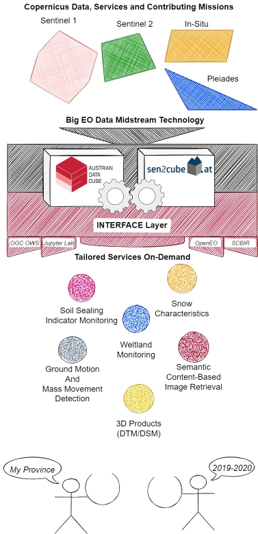
INTERFACE - proposed Solutions
The proposed “INformaTion accEss seRvice For Austrian CopErnicus and contribution missions data“ (INTERFACE) addresses all of the previously mentioned challenges in a systematic manner via agile and continuous involvement of the public sector to implement service prototypes. The focus will be on user-centric interfaces and data standards with special attention to integrating different data sets and setting up a prototype system that allows the systematic generation of higher level information products. During a consultation phase while preparing for INTERFACE, we have identified the following initial specific products:
- Indicating and monitoring sealed surfaces based on Sentinel-2 and on-demand VHR Pleiades access for verification
- Wetland monitoring service using Sentinel-1
- Snow characteristics service using Copernicus Sentinel data and information
- Semantic content based image retrieval system for automated provision of cloudfree Sentinel-2 data before and after an event based on a user-defined date
- Ground motion and mass movement detection service based on Sentinel 1 InSAR data
- Service for deriving on-demand high resolution 3D products (DSM and DTM) from Pleiades (Tri) - stereo data
We intend to tackle the above-mentioned challenges by considering the lessons learned from developing search and access interfaces based on interlinked EO data cube solutions. Additionally, we aim to set up a flexible system that allows us to expand the INTERFACE service prototype with additional information and data layers, e.g. from other existing or future ASAP or Horizon projects. This would provide the public sector one interface at their disposal towards several EO-based developments within Austria. These developments will significantly contribute to lowering the entrance barrier to accessing data and products from Copernicus and contributing missions as well as ASAP results in general. Furthermore, through its close connection to European scale activities, like the ESA openEO Platform (https://openeo.cloud/) and the Horizon C-SCALE project (https://c-scale.eu/), INTERFACE will establish a link to European initiatives like the EC Destination earth activities, the ESA Network of Resources, the ESA Data Hub Relay activities and the European Open Science Cloud (EOSC).